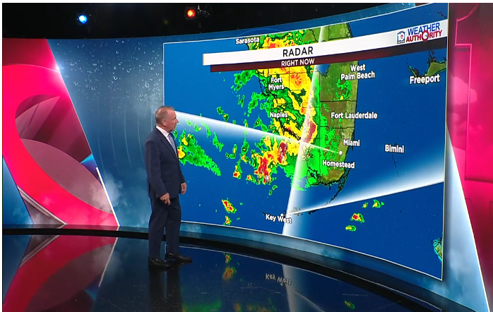
Additional showers and thunderstorms are forecast to move across South Florida on Saturday, raising concerns about renewed flooding in communities where standing water remains after several consecutive days of heavy rainfall.
Meteorologist John Gerard said the next round of rain and storms is expected to reach the Everglades around 9 a.m. before moving eastward across the rest of South Florida between approximately 10:30 and 11 a.m.
The weather system is forecast to move through the region fairly quickly, with the most widespread activity expected around midday. Showers and thunderstorms could continue until approximately 3 or 4 p.m.
Despite the relatively short duration of the storms, Gerard cautioned that additional rainfall could aggravate flooding in neighborhoods where water levels have remained elevated.
Some areas could receive between half an inch and 1 inch of rain over a brief period, potentially causing floodwaters to rise again in communities already affected by recent downpours.
The National Weather Service has issued a Level 1 out of 4 flood threat for portions of Miami-Dade and Broward counties, representing a marginal risk of excessive rainfall.
The latest forecast follows a temporary break in the unsettled weather that provided some South Florida communities with drier conditions Friday and overnight.
However, Gerard explained that the relatively brief period without rainfall was insufficient to produce significant improvements in neighborhoods where floodwaters have yet to recede.
Scattered showers and thunderstorms are expected throughout the day, with some locations potentially experiencing intense downpours and lightning.
Saturday’s weather could also interfere with outdoor activities surrounding the Miami-Virginia Tech football game scheduled for the evening.
Gerard said thunderstorms could affect tailgating events around 4 or 5 p.m., although weather conditions are expected to improve before the scheduled 7 p.m. kickoff.
While the possibility of additional flooding remains a concern, the system’s anticipated rapid movement could help reduce the length of time individual communities experience heavy rainfall.
Residents living in flood-prone neighborhoods are advised to remain attentive to changing weather conditions and the possibility of additional water accumulation throughout Saturday.